| ROAD and TRAIL CLOSURE – SUMMER 2026 Construction of Shotgun Cove Road Extension Phase I (Mile 2.0 to 3.0) will resume at the end of April, 2026 and include closure of the terminus of Shotgun Cove Road (Mp 1.5) and the Emerald Cove Trail for clearing, excavation, and blasting. To ensure public safety during construction activities, public access will be prohibited. For any questions or additional information regarding this project, please contact QAP at (907) 223-3431. |
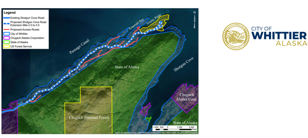
In the fall of 2018, the City of Whittier completed construction on a 2.0-mile segment of Shotgun Cove Road, from Blackstone Road to Second Salmon Run. This first segment of road created access points to Passage Canal at Lu Young Park and to uplands at Cove Creek and Second Salmon Run.
With the goal of increasing access to federal and state lands, expanding opportunities for residential and commercial development, and alleviating pressure on the regional transportation systems, the City applied for and obtained funding from the Federal Land Access Program (FLAP) for permitting, design, and construction of the Shotgun Cove Road Extension (Mile 2.0 to 4.5) from the existing terminus to Forest Service lands at Trinity Point. The proposed project is focused on providing access to federal and state coastal lands and uplands along Passage Canal, on Trinity Point, and within Prince William Sound; and providing access to City land for commercial or residential development as required by the 1994 agreement with the State of Alaska.
The project would construct a new two-lane gravel road that extends approximately 2.5 miles from the existing Shotgun Cove Road terminus to Trinity Point, running parallel to Passage Canal, as well as adjoining access roads and recreational facilities. The City of Whittier has contracted with CRW Engineering Group, Inc. to provide engineering and design services.
To learn more:
- Review project documents and timelines.
- Contact us with questions about the project.
- Review more information about funding sources and partners on the City of Whittier website.
QUICK PROJECT FACTS
Project Purpose:
Access federal and state lands, expand opportunities for residential and commercial development, and alleviate pressure on the regional transportation system.
Design Details:
A two‐lane, gravel road from the end of the existing Shotgun Cove Road to Forest Service land at Trinity Point.
By the numbers:
Mainline approx. 2.5 miles
Access Roads approx. 2.0 miles
8 Proposed Recreation Facilities
Funding Source:
Federal Highway Administration Western Federal Lands grant
Proposed Schedule:
Final Design – Fall 2024
Phase I (Mile 2.0 to 3.0) Bid Documents – May 2025
Phase I (Mile 2.0 to 3.0) Construction – Summer 2025-26
Map of the Project Area